Impact of Transit Priority and Transit Autonomy on Vision Zero
Stephen Christopher Siciliano
A thesis submitted in partial fulfillment of the requirements for the degree of Master of Urban Planning, University of Washington, 2026
Abstract
Vision Zero—the goal of eliminating traffic fatalities and serious injuries—is proving to be challenging for cities. At the same time, the field of autonomous vehicles (AVs) is rapidly evolving and will profoundly affect transportation systems. With a reduction in perceived cost of travel time, AVs will likely increase traffic. This thesis investigates how Seattle can pursue its Vision Zero goal in the context of the rollout of AVs. Informed by practitioner interviews, I modeled two key interventions: converting all buses to driverless operations across several different network designs, and implementing ubiquitous transit priority. I used the Puget Sound Regional Council’s Household Travel Survey data to create a multinomial logit model that predicts travel behavior. Then, I simulated trips accounting for changed transit travel time and the effects of congestion. I found that both interventions can reduce transit travel time by up to 33%, while transit mode share increased by only 2.5pp. The congestion effects of AVs and transit lanes reduced the average speed of vehicles in the city, resulting in a scenario that yields up to a 35% reduction in fatalities. These results suggest that policymakers should pursue policies that manage vehicle speeds first and foremost, and that faster, more frequent transit can be an effective way to keep people moving even if their personal vehicle is speed-constrained.
The Problem
American cities today face many challenges in providing a safe and healthy environment for residents of all ages. In 2024, nearly 40,000 people in America were killed by motor vehicles on streets (National Center for Statistics and Analysis, 2025). Car crashes are a leading cause of death for younger people (National Highway Traffic Safety Administration, n.d.), and in addition to the fatalities, car crashes cause serious injuries that can dramatically impact people’s quality of life. This level of traffic violence is not a given; countries like Norway have demonstrated that this high rate of mortality is avoidable (Elvik & Nævestad, 2023)—Norway has 3.7 fatalities per billion VMT (Flotve, 2025) (Statistics Norway, 2025) compared to 12.6 per billion VMT in the United States (Federal Highway Administration, 2025). This high rate of fatalities and injuries is an artifact of the transportation systems that American cities have been building for over a century, and specifically, the overwhelming priority that the built environment provides for personal motor vehicles.
Recent years have seen the automotive industry propose privately owned or rideshare-style automated vehicles as the solution for Vision Zero. Companies like Tesla and Waymo propose that vehicular autonomy will make it less likely for cars to hit pedestrians. In this thesis, I do not attempt to challenge that assumption; although there are examples to the contrary, I consider it a given that automated cars can reduce road deaths. However, the question is not whether it is possible for only one approach to achieve Vision Zero, but whether that approach will maintain (or even enhance) equitable mobility for residents. Fundamental limitations on street width mean that a city full of cars that are affordable, personal, and autonomous may have worse congestion than the cities of today. That is because automated vehicles will reduce the perceived cost of travel. Economic theory suggests that when something becomes less expensive, there will be more of it (Naumov et al., 2020). Thus, AV-driven induced demand could reduce average vehicle speeds in cities. This will make it more critical than ever to have prioritized street space for higher-capacity vehicles like buses to maintain mobility.
Research Question
This research project examines two interventions in a world of ubiquitous private automated vehicles: autonomous public transportation and physical priority for public transit in street infrastructure (put simply: bus lanes and TSP). Specifically, the research question I answer is: How can a combination of automating public transit and allocating street space to buses help Seattle achieve Vision Zero while maintaining its transportation goals?
Method
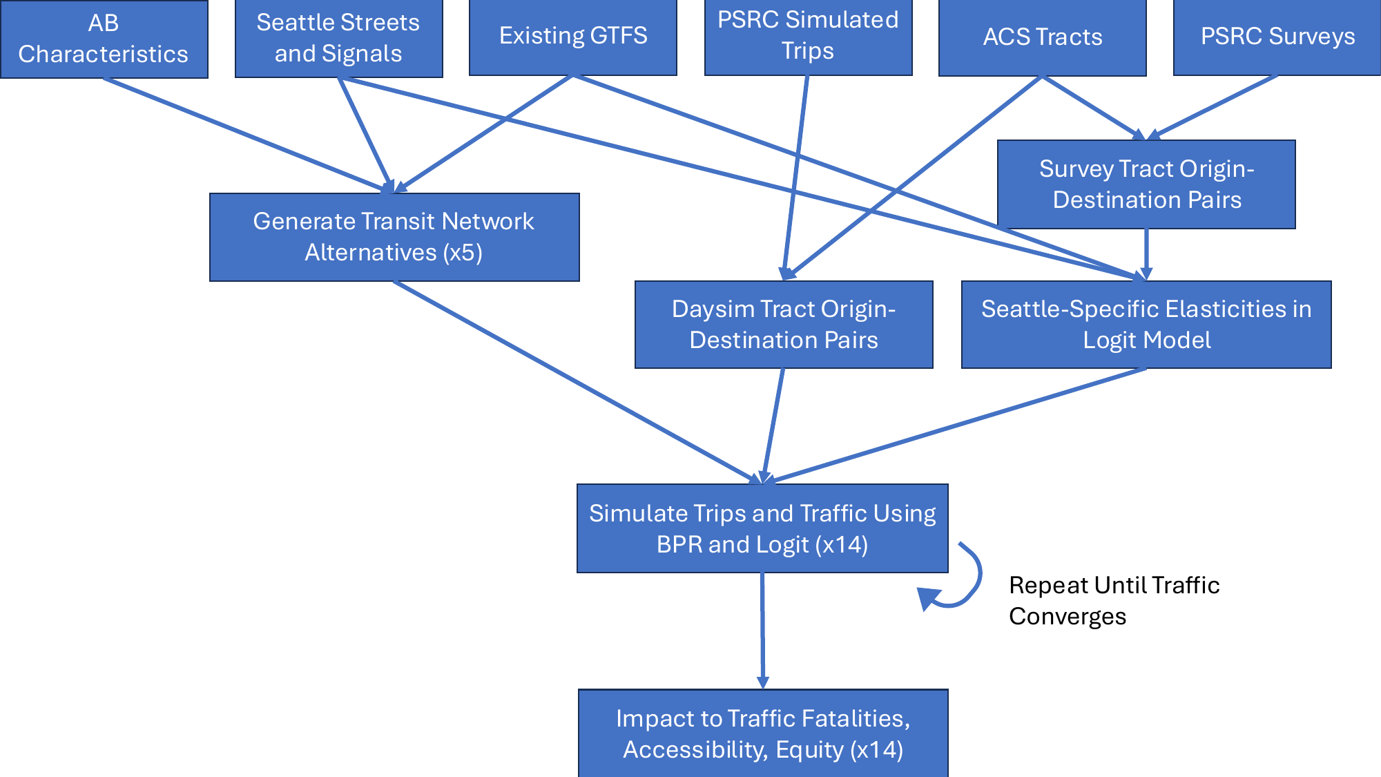
This research is broken into four distinct parts: 1) creation of a logit model predicting travel behavior in the City of Seattle, 2) creation of a model for transit priority in the city, 3) creation of new transit networks based on the characteristics of Automated Buses (ABs), and then 4) analysis of what changes in travel patterns will happen based on these different hypothetical networks. All code for these calculations is written in Python and R, and is available on GitHub at: https://github.com/ctachme/transit-priority-vision-zero.
Results
In the most optimistic case, this constitutes a 35% reduction in fatalities and a 25% reduction in serious injuries. These numbers are less than a 17% reduction in speed would imply because traffic fatalities are not evenly distributed throughout the day (Seattle Department of Transportation, 2026e). See the below table for the breakdown by time of day.
| Time of Day | Speed Change | VMT Ratio | Fatalities (baseline) | Fatalities (projected) | Serious Injuries (baseline) | Serious Injuries (projected) |
|---|---|---|---|---|---|---|
| AM peak | –19.9% | 1.088 | 2.62 | 1.46 | 21.8 | 15.3 |
| Midday | –15.5% | 1.05 | 6.41 | 4.06 | 59.7 | 44.8 |
| PM peak | –17.8% | 1.057 | 5.5 | 3.23 | 49.7 | 35.5 |
| Evening | –9.1% | 1.007 | 6.47 | 4.89 | 44.1 | 36.7 |
| Night | –14.3% | 1.025 | 8.41 | 5.42 | 47.5 | 35.7 |
Ultimately, bus network design—despite being a key aspect of this thesis—did not have a significant impact on the Vision Zero results. This is because the primary cause for improvement is the decrease in vehicle speeds (not VMT) which the different bus networks do not meaningfully modify. As called out in the methods section, the impact to fatalities is an approximation—but it still demonstrates the possibility for significantly-reduced fatality risk.
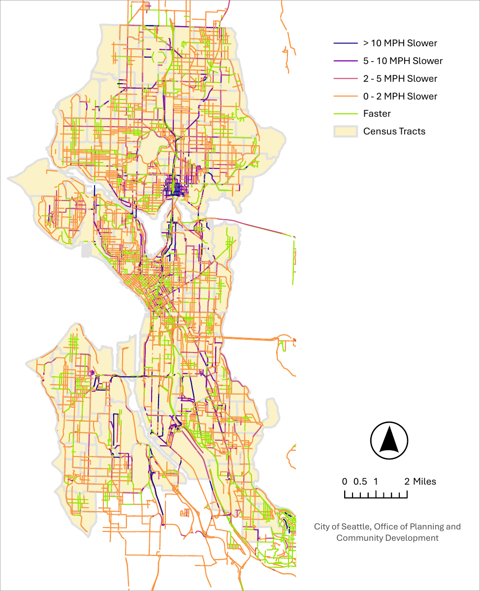
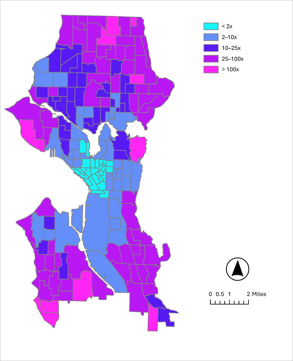
The downtown area saw the smallest improvement in transit accessibility. This is likely because that portion of the city is already well-served by transit. The greatest improvement tends to be in the perimeter of the city that has poor transit access today. Contrasting this with drive accessibility it has the opposite effect where there are perimeter areas that have a greater decline in accessibility.
Discussion
Although the bulk of this thesis is focused on modeling transit networks, the strongest result identified is the impact of speed on fatalities and serious injuries (which does not inherently require improved transit). Reallocating street space away from cars adds to congestion, resulting in somewhat slower vehicle trips. Since fatalities scale by v3, even a modest reduction in speed can have a huge impact on safety. From a policy perspective, this means that similar Vision Zero results could be achieved by reallocating street space for other purposes, such as bike lanes, outdoor dining, or parklets. Ultimately, transit remains the most efficient way to move people, so reallocating that space to transit furthers the mobility goals of the city while simultaneously helping the city achieve Vision Zero.
It is worth noting that these results are based on the network-average speed. There are many factors that go into making a street dangerous, and this thesis did not model any of those additional factors. This makes the results a directional proxy for what is conceivable, not a specific guaranteed number.
Limitations and Further Research
Data
This thesis relies heavily on the PSRC Household Travel Survey which extrapolates to Puget Sound-wide trips from a small sample (there are 12,118 households in the sample, of which only 6,215 are in Seattle). The small sample size reduces the predictive power of subtler elements of the model (for example, the relationship between different demographic characteristics). There are non-public datasets available with much richer O-D info, for example, collected from cell phone usage. If funding were available, using these datasets would have enabled a more reliable set of trip calculations. Use of the survey data also has the potential to introduce a temporal mismatch: the street and transit networks are based on what is on the ground in 2026, whereas the PSRC data goes back several years.
Policy Acceptance of Transit Priority
The most significant conclusion from this thesis is that reallocating street space to public transit makes streets safer by increasing congestion and reducing vehicle speeds. It is an open question whether or not the typical Seattleite would accept this tradeoff. I would suggest public outreach to ask the question: “Would you accept slower drive times if it made our streets safer and resulted in much faster transit times?” The numbers are powerful and most people know at least one person affected by traffic violence. However, when confronted with a real tradeoff, enthusiasm may wane. Understanding people’s sensitivity to the tradeoff could help policymakers understand the boundaries of what an acceptable intervention would be.
Sources of Anti-Transit Bias
The model suggests that people’s mode choice is driven by factors beyond time and cost alone; in fact, travel time only predicts a small part of the decision to drive. Yet at the same time, there are places in the world where transit mode share is much higher than driving mode share, so these biases are not fixed. Additional research should be done comparing the Puget Sound to other worldwide locations with higher transit mode share to understand what is missing from an analysis like the one in this thesis.
Conclusion
This thesis found that reallocating street space to purposes other than cars is the primary modeled pathway that reduces fatalities and serious injuries in the transportation network. I evaluated 14 different scenarios, looking at the presence or absence of personal AVs, whether there are transit lanes, and four different layouts for the bus routes in the city. These layouts have roughly equal vehicle requirements, so there is no expectation of a funding influx here. The best models saw a 35% reduction in fatalities and a 25% reduction in serious injuries. This meant that cars would get around more slowly, with a 17% reduction in vehicular speeds. On the other hand, transit could reach much more of the city more quickly: the median transit trip could be 33% faster and people could access 249% more jobs in 30 minutes or less.
Ultimately, this thesis does not investigate whether the people of Seattle would accept such a change, but it does provide a quantitative representation of one possible path: a future in which people can be much safer on the city’s streets and can get around quickly and easily with high-quality public transportation. Returning to the original research question, I found that allocating street space to buses does advance Vision Zero, while automating transit improves mobility but does not directly help improve safety in the city.